Thanks to all who followed this series. For new viewers, you can start touring the Sunshine Coast,
British Columbia, Inlets from the beginning HERE.
I have now started another photographic tour that you can follow at:
Hard-To-Come-By Lifestyle


Thanks to all who followed this series. For new viewers, you can start touring the Sunshine Coast,
British Columbia, Inlets from the beginning HERE.
I have now started another photographic tour that you can follow at:
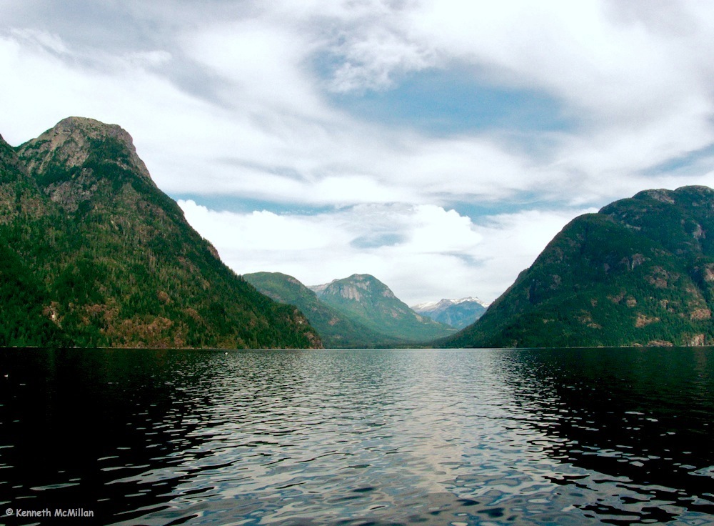
From Agamemnon Channel we turn about and head home, slipping safely through the Skookumchuck Rapids, winding down Sechelt Inlet to Porpoise Bay and the Lighthouse Marina. This is the end of the tour and I’ll leave you with a few more photographs.
Thanks for participating and following along. I’ll soon be starting another blog a little closer to home – a photographic tour of our acreage. I’ll post the information here once I’ve started it.
Thanks again – Ken
Travelling 28 miles (45 km) south from Deserted Bay, passing more majestic scenery, brings us back to the ‘intersection’ of Jervis Inlet, Sechelt Inlet and Agamemnon Channel. There are just a couple of stops to see in Agamemnon Channel before returning home to Sechelt Inlet.


Agamemnon Channel is a 9.95 mile (16 km) narrow channel separating Nelson Island from the mainland. At the southern end it opens out into Malaspina Strait which lies between Nelson Island and Texada Island. Because of it’s narrowness Agamemnon is affected by the tides and, while they aren’t a problem for power boats, kayakers may want to check the tide charts before passing through. It is a much easier paddle when going with the tide rather than fighting it.


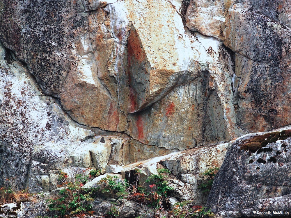
At the northern end of Agamemnon, on the mainland side, is the BC Ferry Terminal at Earl’s Cove. From there you can take a ferry to Powell River, BC. Very near to the ferry terminal are a set of pictographs thought to be the oldest pictographs in all the inlets.


5 miles (8 km) south of the Earl’s Cove pictographs are another set found in a cave about 15 feet above sea level.
Continuing south out of Agamemnon there are other pictographs to be found in the area as this was a major gathering place for the shíshálh (Sechelt) in the winter months.
Cruising up the last 8 miles (13 km) to the head of Queen’s Reach took us past more wonderful sights – flowing mosses hanging from the shoreline trees, basking harbour seals, an old mine carved just above the tideline and the usual mountain vistas. On reaching the end we were the furthest distance from our house, only 50 miles (80 km) – as the crow flies – with all this amazing beauty in between.


The head of Queen’s Reach was once another village of the shíshálh. This one was the home of the Xénichen sub-group and the village was called Hunaechin. Mount Victoria at 6,850 feet (2,088 meters) dominates the view but an impressive Mount Alfred, 7,940 feet (2420 meters) can be seen over to the left.


Mount Victoria
Coming back down the upper shoreline of the reach there is another set of pictographs. These are the brightest coloured of any we found.


About 7 miles (11.2 km) down from the head of Queen’s Reach is the entrance to Princess Louisa Inlet guarded by the Malibu Rapids. The Malibu Rapids are another short tidal entrance that must be entered with caution and only at slack tide. Sitting on the rocks above the rapids is the Malibu Club which is a Christian retreat centre for youth, owned by the Young Life Society.
The retreat was once the home of Thomas F Hamilton, the inventor of the variable pitch airplane propellor. In the 1930’s Hamilton spent over $2,000,000 creating his luxury resort – building a 9 hole golf course, beaches, tennis courts, etc. The rich and famous would fly in to stay in the luxurious, rustic setting for $250 a day. The resort opened in 1941 but only ran for a couple of years. When WW II broke out the resort hit a financial downturn. It opened again from 1945 to 1950 entertaining such people as John Wayne, John F Kennedy, Bing Crosby and Bob Hope. Because of the difficulty of travel and a short weather season the resort hit another downturn and closed in 1950. Hamilton put the property up for sale in 1951 for $1,000,000. In 1954 the Young Life Society bought the property for a reported $300,000. It now runs as a year round camp.
Inside the rapids is the famous 5 mile (8 km) long Princess Louisa Inlet with the 120 foot (37 meter) Chatterbox Falls at the end. The area around the falls is part of the Princess Louisa Marine Park which is managed in cooperation with the Princess Louisa International Society. As mentioned in an earlier post, 2,755 (840 meters) James Bruce Falls is to the left of Chatterbox Falls. It is thought to be the tallest falls in North America.
Princess Louisa can be a very busy place for boats in the summer. We didn’t visit there mainly because of that reason but also because it was late summer and the falls weren’t at their best. Boat tours to Chatterbox Falls can be taken from Egmont in the spring and summer on the Malibu Princess.

Malibu
Heading south down Queen’s Reach you arrive at Deserted Bay or Skwáh-kwee-em. This was the home of the Ts´únay, another sept of the shíshálh and it was one of the largest villages of the shíshálh’s.
Deserted Bay has seen a variety of activities. Logging started in the early 1900’s and continued throughout the years and in 1904 a salmon salting factory opened and ran until 1907. In 1910 a slate deposit, previously used to make Indian arrowheads, was “re-discovered” and a slate quarry established but it closed in 1916. In 1988 the Sechelt Band opened an outdoor education school at Deserted Bay on the site of an old logging camp. It was later converted to a drug and alcohol rehabilitation centre for a short time.
When we anchored in the bay it was absolutely still and quiet. All we could hear was the Deserted River flowing into the bay. A beautiful place to kayak.
Continuing up the left side of Prince of Wales Reach 1.5 miles (2.4 km) brings you to the Brittain River and the start of Princess Royal Reach. Brittain River is the site of another deserted shíshálh (Sechelt) village, Sláy-ah-thlun that was famous for it’s dugout canoe makers. Logging has taken place in the area since the 1930’s and no trace of the village remains.


Princess Royal Reach continues to have incredible scenery with steep and unusual rock outcrops. We found two more sets of pictographs and missed one more. Ten miles (16 km) up the Reach you turn left around Patrick Point and enter Queen’s Reach.


We travelled another 3.4 miles (5.4 km) and anchored in front of an old homestead. Again weather was favourable and we had a beautiful afternoon and evening there. We kayaked a little further up the inlet and found an old logging camp with lots of discarded equipment left in the bush. Unfortunately this was not an uncommon practice – it was cheaper to just leave the equipment rather than haul it out.


We also found lots of erratic boulders along and under the waterline. Many of them were massive chunks of rock piled on top of each other descending into the depths. The trees were also amazing to see, growing right down to the tideline. These would be second growth timber as most of the accessible old growth trees in all the inlets had been logged out in earlier times.


Prince of Wales Reach
Once leaving Vancouver Bay you enter into Prince of Wales Reach. Again the steep mountains make a dramatic backdrop. Moorsam Bluff on the right rises sharply 4900 feet (1500 meters) from the ocean. On the left are slightly lower cliffs and about 4 miles north of Vancouver Bay are another set of pictographs.


When we planned our cruise up Jervis Inlet our intention was to take it slowly and explore the inlet thoroughly. We travelled very close to the shore which was easy to do because of the depth of the water, cruising at about 4 knots (4.6 mph) and poked into every bay and crevice. We were fortunate with the weather because all of the Reaches have very few places to anchor, especially if any wind is blowing. I had read in boating guides of a couple of lesser known spots and they worked out well, but only because of the calm weather.

“Jazz Age” – The Bight at McMurray Bay

Low Tide
One beautiful spot was just past McMurray Bay on the west side of Prince of Wales Reach, 3 miles (4.8 km) past the pictographs. McMurray Bay is a beautiful little spot with enough room for one boat and when we arrived there was a boat already anchored. I had read about two small bights (bays) just past McMurray. One was to be avoided because of lots of rocks but the other was suitable for anchoring in calm weather and that’s what we did. It was a beautiful spot with great views up and down Prince of Wales Reach.

McMurray Bay Sunrise – looking north

McMurray Bay Sunrise – looking south

From Granville Bay, heading east 5.6 miles (9.2 km) you arrive on the east side of the mouth of the reaches of Jervis Inlet. Heading north you enter the deepest fjord in British Columbia, measuring 2402 feet (732 meters) deep. Quite dramatic when you consider some of the walls of the fjord rise over 5900 feet (1800 meters) almost straight up out of the water. Like the other inlets in the area, Jervis Inlet was carved out by glaciers following ancient river valleys to the sea. It is made up of three arms or reaches – Prince of Wales Reach, Princess Royal Reach and Queen’s Reach. Each reach makes an almost right angle turn from one to the other.
Princess Louisa Reach is a side inlet off Queen’s Reach. At the end of Princess Louisa Reach is Chatterbox Falls, a popular tourist and boater’s destination. Near to Chatterbox Falls is James Bruce Falls, thought to be the highest waterfall in North America at 2755 feet (840 meters).
Heading north up the mouth of Jervis Inlet 7 miles (11.24 km) you will find another set of pictographs about 40 feet (12 meters) above the waterline. Another mile further is the entrance to Vancouver Bay. On the north side of the bay is Marlborough Peak, 5905 feet (1800 meters). Turning into the bay offers a beautiful view of Mount Churchill, 6562 feet (2000 meters) and the Vancouver River Valley.

Mount Churchill and the Skwákwee-em Healing Center in Vancouver Bay
Vancouver Bay was another seasonal village of the shíshálh’s (Sechelt’s) and was known as Skwákwee-em. As with other village sites in Jervis Inlet, Skwákwee-em was located where there was a good beach, a supply of fresh water and favourable conditions to be able sustain a village i.e food supply and flat, open space. In the 1860’s European settler’s started to move in and Catholic missionaries arrived to ‘improve’ the lives of the locals. Unfortunately, one of the first things they brought was a smallpox epidemic that wiped out 90% of the native population. By the 1881 census only 167 members still survived. It was thought it was best to gather the remaining members to one central location (Sechelt).
Father Paul Durieu converted the remaining band members to Catholicism and started the now controversial residential school system. In 1904 a residential school was built in Sechelt and native children were taken from their homes to attend. The children were only allowed to speak English (even to their parents) and weren’t allowed to go home. Parents could have a supervised visit only once a week for an hour or two. The school operated right up to the 1960’s. All traditional native artifacts were destroyed and native ceremonies were banned.
In the meantime, the new white arrivals realized the economical benefits of the old growth timber all along the inlet shore. Logging camps started up and the most logical sites were the Indian villages. In most cases the native habitations were razed and the camp was built over the site. Sympathetic attitudes towards native culture was sadly lacking during this period. I’ve read accounts of logging companies bulldozing and flattening 30 foot middens to build camp work yards. Skeletons and artifacts from native burial sites and villages were taken with little thought and sold or given to museums. This continued right up to 1960 when the British Columbia Archaeological & Historical Sites Act came into law.

The Vancouver River Valley
In Vancouver Bay the first logging camp was started in 1889. By 1905 there was a narrow gauge railroad running up the Vancouver River Valley to haul out logs. Between 1926 and 1930 more than 700 men with their wives and children were living in Vancouver Bay. By 1980 the logging was done and the valley is quiet once more. Vancouver Bay is still part of the shíshálh (Sechelt) reserve system and in 1983 a native healing centre was started there.

The mouth of Vancouver Bay

Approaching the Harmony Islands
Heading down the east side of Hotham Sound 4.7 miles (7.6 km) brings you to the Harmony Islands Marine Park. These are a cluster of four small islands, two privately owned and two belonging to the park. In the channel between the islands and the mainland there is plenty of room to anchor and stern tie to shore and it can be quite a busy place in the summer. The largest island has a grassy area for camping and it is a great place for kayaking, snorkeling and swimming. Towering over the islands is 4600 foot (1400 meter) Mount Calder. The park is a wonderful place to take in the vistas of Hotham Sound.

The channel between the islands and the mainland – a very sheltered moorage

Friel Falls – not much water flowing when this was taken
A mile south of The Harmonies is Friel Falls which plummets 1,475 feet (450 meters) down a sheer cliff onto the shore. Very dramatic, especially during the spring melt and after heavy rains.

Granville Bay

At the old homestead
Two miles (3.4 km) further south is Granville Bay, the site of a lovely old homestead dating back to 1898. This belonged to the Hollingsworth family. At one time there were extensive gardens and apparently Mrs. Hollingsworth would play piano and entertain the local loggers and miners in grand style. In recent year it had become an oyster farm but it was no longer working when we passed through.

In the main body of Jervis Inlet, heading north, you have the choice of going up Hotham Sound or the reaches of Jervis Inlet. When we did our initial cruise we headed to Hotham Sound first.
From the mouth of Hotham Sound to the end at Baker Bay is approximately 8 miles (12.8 km) and it is a quite sheltered, beautiful cruise. Coming around Syren Point you look right up the Sound to two bays at the end – Lena Bay is on the right and Baker Bay is to the left. It is a very dramatic sight with the Parker Mountain range towering 3600 feet (1100 meters) on the west side of Baker Bay. We anchored in Baker Bay which proved to be a bit tricky. Some books say that it is not advisable to anchor there because of poor holding conditions but I had read an account of an old timer on how he had done it and it worked for me after a couple of tries.


In 1912 a copper mine was started at 1500 feet above the bay. In three years, 330 feet of tunnel had been dug but not enough mineral was found to make it viable and the mine closed in 1916. There is a very overgrown road that heads toward the mine site but we never made it to the mine and I’m not sure if you can get to it.
We did explore the unusual dry river bed that runs up the valley. This was July and near the ocean a wide fan of rounded large river rock fanned out through the trees, quite a distance from the main river bed, indicating that large and powerful amounts of water carried the rocks there. However, when we walked the river bed we had to go up more than a mile before we found any water flowing at all and even then it was just a small stream. The only way to account for the size of the river bed is a heavy snow melt in the spring.


On the east side of Baker Bay is a wonderful lagoon, easily accessible by kayak. When the tide is low the water warms up and it is a great place to swim. The sheer towering cliff overlooking the lagoon makes an impressive backdrop.


Egmont Boat Houses
After going through the Skookumchuck Narrows and passing the community of Egmont there is a ‘crossroads’ of inlets. Behind you is Sechelt Inlet, ahead is Jervis Inlet, to the left Agamemnon Channel and to the right Hotham Sound and the entrance to the reaches of Jervis Inlet.

Jervis Inlet
When Captain Vancouver surveyed this area in June of 1792 he did so by a 25 foot rowboat launch and a crew of thirty. They had left his ship near what is now the US border and had rowed up the coastline, charting along the way. When Vancouver saw the entrance to Jervis Inlet he was hoping he had found the Northwest Passage. As exploration of the area began a strong rain and wind came up and they made a run up Jervis Inlet, ignoring Sechelt Inlet entirely. Finally, after rowing 40 miles (65 km) up the twisting inlet they reached the end and, much to Vancouver’s disappointment, he realized he hadn’t found the Northwest Passage.

The entrance to the reaches of Jervis Inlet
A photographic tour of our homestead
The many adventures of a first time homesteader
Life on the Celtic Fringe
Writer on the Edge
Homemade and Homeraised is what we strive for.
Fotografías de Calvipitecus
The good life. Gardening in Eden.
Life as I see it
A collection of beautiful things and thoughts
Simple Living for families that is easy and eco-friendly
Living Naturally, Anywhere
A spotlight on nature and the outdoors, blurring the lines between photography and art
Cuando Lo Pequeño Se Hace Visible...
notes from a Swedish amateur photographer © Ulrika Undén
Macro Photography - of the wild life at our feet, its reflective nature and practical value - a meditation.
